
For more than a century, giant patterns and pictures sketched into the plains south of Lima, Peru, have mystified archaeologists. Named for their makers, the Nazca people who lived between 200 BC and 650 AD, the ‘Nazca lines’ remain one of archaeology’s greatest mysteries.
With the arid ground as their canvas, ancient Peruvians worked on a scale so vast that many of their designs can only be fully admired and appreciated from the air – ironically, a viewpoint the artists never had.
“Flying over the dramatic desert plains… one sees strange and unique networks of lines and geometric figures,” wrote Long Island University history professor, Paul Kosok, in 1959. “They’re visible in many places; sometimes lacing back and forth in extremely complex and apparently chaotic ways...”
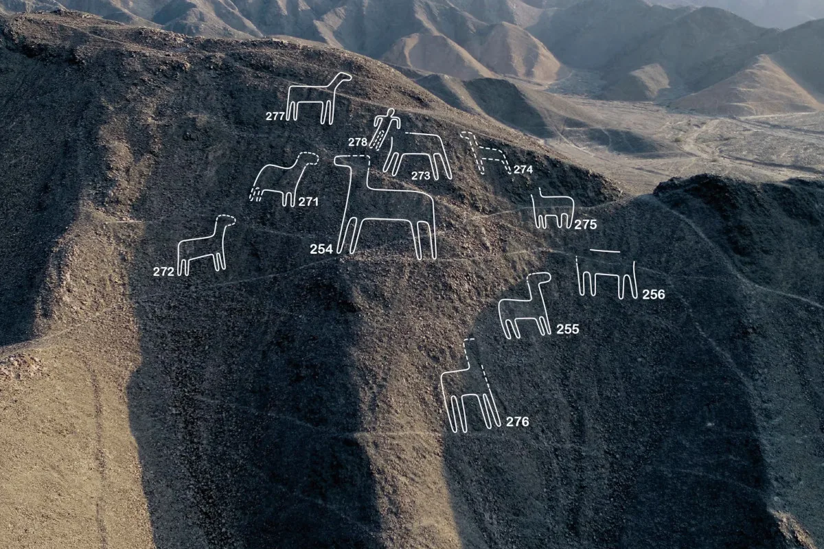
The ‘geoglyphs’ (meaning ‘earth markings’) cover at least 450km² (almost 175 miles²) of desert, many depicting people, animals, plants and tools. Since the 1940s, around 430 of these fascinating ‘figurative’ examples of Nazca lines have been discovered through ground and aerial surveys, but their meaning is still debated.
Now, though, archaeologists are turning to machines to help them solve this ancient puzzle.
Working with IBM scientists, European and Japanese researchers have taught artificial intelligence (AI) to spot the geoglyphs within vast swathes of aerial imagery, offering new insights into the Nazca lines’ purpose.
Prof Masato Sakai, from Yamagata University’s Institute of Nazca in Peru, explains it took his team just six months to discover 303 more figurative geoglyphs – almost doubling the previous total. “The ability to conduct the [survey] in such a short period was thanks to the use of AI,” writes Sakai, who was working in the field when BBC Science Focus contacted him for an interview.

But the Peruvian desert isn’t the only place where AI is helping to find and interpret artefacts our ancestors left behind. It’s already learning to recognise all kinds of historical remains, from burial mounds to shipwrecks.
According to Sakai, “AI excels at efficiently processing large amounts of data” and its use in archaeology will increase dramatically.
Ancient history
The story of the Nazca lines is one that unfolds over three eras of human technological advancement. In the first, the Nazca – often said to be a technologically advanced people, who also made beautiful textiles and ceramics – created the lines.
They drew spirals, stars and trapezoids, and depicted birds, monkeys and scenes of human sacrifice, to describe just a few. The geoglyphs were made by removing the top 30–40cm (approx 1–1.5ft) of brown dirt and pebbles to reveal the light-coloured clay and lime beneath.

Kosok’s collaborator, Maria Reiche, a German mathematician and astronomer who spent decades studying the lines, described their proportions as “perfect”, suggesting the Nazca people carefully planned and measured out their designs using ancient tools and units of measurement.
When Nazca society collapsed, many of their drawings stood the test of time thanks to the dry climate and, as Reiche observed, slight stickiness of the gypsum-containing soil, which “affixes every stone to its base.”
Fast forward to the 20th century and humans have mastered flight. In this second, airborne era, the true scale and complexity of the Nazca lines is revealed. It prompts Kosok and Reiche to suggest they formed part of a vast astronomical calendar, noting important stars, or the sunrise on the solstice – a theory that has now mostly been dismantled.
Others have argued they were signposts to water, ritual walkways or messages inscribed for the Nazca’s gods (or for alien contact).
Since 2004, Sakai’s group has relied on imagery from satellites, planes and drones to uncover more geoglyphs, but the Nazca region is so vast that it can’t be searched in detail by humans.
Now, though, in the third technological era, the power of AI and machine learning is being harnessed, enabling archaeologists to search at scale. “Conducting distribution surveys solely with remote sensing technology would take an enormous amount of time,” Sakai writes. “We introduced AI to conduct the distribution surveys faster and more efficiently.”
Read more:
- Is AI taking away jobs?
- AI trained to spot brain tumours faster than humans
- AI technology could turn thoughts into speech
Aiming high

Starting in 2018, Sakai and his team tested automated techniques on a 27km² (10 miles²) patch of desert and found four new geoglyphs. The more recent flood of discoveries, announced in September 2024, comes from applying similar technologies to spot geoglyphs across the entire Nazca region.
AI suggested 178 of the confirmed findings, including some that formed part of larger collections – leading to another 66 discoveries on the ground. As Sakai notes, “The final verification of AI’s results must be done by humans.” The remainder were found in the field without AI’s help.
The emergence of AI techniques in archaeology marks further progress in the digitalisation of a domain that was for so long reliant on tape measures and hand-drawn plans.
Over the last decade, archaeologists have increasingly adopted digital tools that can map, record and visualise historical sites.
“We started moving from drawings to photogrammetry [a 3D-modelling technique]. Now we’re working with remote sensing data and machine learning,” says Dr João Fonte, an archaeologist with Portuguese archaeology company, ERA Arqueologia. “Within the humanities, I think archaeology is really at the forefront of innovation.”
At the same time Sakai’s group was running its earliest AI tests, Fonte was at the University of Exeter, where he started talking with ERA about the idea of combining AI with remote sensing.
The discussions led to the Odyssey project, in which archaeology and AI experts collaborated to teach machine learning algorithms how to recognise different types of archaeological sites.
Their most recent study demonstrates an AI system that detects hillforts – enclosed settlements found on hilltops – based on aerial survey data that takes into account elevation changes, even below the vegetation level.
The system learns to identify the sites not just by how they look, but also where they are in relation to other features in the landscape.
As Alberto Lago da Silva, a consultant at ERA, explains, the Odyssey project aims to develop AI that makes inferences using a combination of different types of information, like human experts do.
“You need experience to spot sites on an image and you have to use resources that are outside of the image,” he says. “You have to understand that this particular spot is beside a river, on a hill slope or near the sea.”
The model found 384 features that looked like undiscovered English hillforts. They were later checked by expert eyes, contained within just 15 per cent of the data that archaeologists had time to look through. The results hint at how powerful AI could prove for large regions where archaeological features aren’t well mapped.
AI marks the spot
By some estimations, detecting giant murals across exposed deserts might be easier than detecting hillforts. As Fonte points out, “[The Nazca lines] are really monumental and spectacular, so I think the tricky thing there is to have good data in terms of the satellite imagery… And with that data, it’s more or less easy to find this kind of archaeology.”
In another example of desert-based detection, in 2023, a team from the United Arab Emirates (UAE) tested AI with satellite data to find archaeological remains in Dubai’s Saruq Al Hadid (Valley of Iron).
The site was a centre for copper smelting between 1270–800 BC and has already proven to be littered with artefacts. Here, automated detection could provide some reprieve for field archaeologists who have to endure heat and high sand dunes to uncover more.
“Our method provides a straightforward indication as to where to concentrate these efforts, instead of searching everywhere,” says Khalifa University’s Dr Diana Francis, a remote sensing expert who was part of the UAE team. Elsewhere, AI could help archaeologists remotely study regions where conflict prevents them from getting fieldwork permits.
AI models aren’t infallible, though. They don’t score a hit every time. In fact, Sakai’s team scrutinised an average of 36 suggestions from their geoglyph detector to find each one that showed real promise. But the sheer speed at which AI was able to comb through aerial imagery freed them up to spend longer confirming their findings on the ground.
Researchers have also increased accuracy by teaching the AI model not just what geoglyphs or hillforts look like, but what ‘not-hillforts’ and ‘not-geoglyphs’ look like as well. According to Sakai, “Training on photographs of areas where no geoglyphs existed, [improved the model’s] ability to judge whether a geoglyph was present.”
Even with low accuracy, though, what AI offers archaeologists might be good enough: more suggestions than they can check, rapidly, and including loads of sites that, in the case of the Nazca geoglyphs, at least, have turned out to be worth following up.
“AI isn’t perfect, especially in archaeology,” says Dr Alexandra Karamitrou, an AI and archaeology expert at the University of Southampton. “But in a few years’ time we might be able to develop algorithms with very good accuracy… helping people save time, energy and money.”
Walk the line

Karamitrou is developing a general-purpose AI tool that finds archaeological features in Google Earth images. Via Zoom, she shares day-glo-coloured, machine-eye views over Olympia in Greece, Egypt’s Giza pyramids and Peru’s Ica Valley (domain of the Nazcas).
The parts the algorithm views as historical sites are coloured green, and it makes plenty of mistakes. But it’s also capable of picking out geoglyphs that are barely visible in the original Peruvian images, demonstrating the potential to be helpful.
The Kwajalein Atoll shipwreck
Although the tool isn’t as well-trained as Sakai’s for detecting Nazca geoglyphs, it could allow archaeologists with no AI expertise to start working with the technology. Meanwhile, Karamitrou has been using the same techniques with sunken ships.
Her 2023 study shows that algorithms can identify the pollution signature of ‘black reefs’ (reefs turned black by the iron contamination from shipwrecks) in satellite imagery and track the spread of the pollution over time.
Globally, the whereabouts of an estimated 2.7 million shipwrecks worldwide remain uncertain. Karamitrou’s work suggests that their location could, potentially, be pinpointed by their pollution signature.
What more, though, can AI detectors reveal about the distant past? What new information can we glean about the Nazcas, for instance, by hunting down more of their already well-known desert drawings?

Well, the number of newly discovered geoglyphs is so large that there’s been a shift in thinking around what they might mean. Sakai’s team previously suggested that certain ‘figurative’ geoglyphs, often depicting people, human sacrifices and livestock, were associated with “a tangled meshwork” of walking trails.
Until now, there weren’t enough of these geoglyphs to prove the theory. But with the new additions, and fieldwork verifying the geoglyphs can be seen from the trails, the researchers confirm they “were objects to be viewed” while walking, even suggesting the pictures acted as a means of communication about the human activities that occurred near the paths.
Today, the Nazca lines face increasing threats from human activities and extreme weather events like flash floods. In a new, pre-print paper, Sakai’s team uses modelling to suggest which geoglyphs could be most at risk from water damage – and how drainage could help preserve them.
Francis, a climate scientist by trade, says AI could also “be of great help” in predicting how climate change could impact specific sites.
Of course, AI’s greatest advantage is its speed, which could help to ensure more archaeological treasures are discovered and protected before it’s too late. With nearly 1,000 suggestions for new Nazca geoglyphs remaining unchecked, however, Sakai’s team will have to step up the pace in the field if they want to save them all.
About our experts
Prof Masato Sakai is an archaeology expert who works for Yamagata University’s Institute of Nazca in Peru. His work has been published in Proceedings of the National Academy of Sciences, Seikei-Kakou and Journal of Archaeological Science.
Dr João Fonte is an archaeologist with Portuguese archaeology company, ERA Arqueologia. He has been published in Archaeological Prospection, Remote Sensing and Conimbriga Revista de Arqueologia.
Alberto Lago da Silva is a consultant at ERA Arqueologia.
Dr Diana Francis is a remote sensing expert and Assistant Professor of Earth Science at Khalifa University, UAE. Her work has been published in Geosciences, Science Advances and Atmospheric Research.
Dr Alexandra Karamitrou is an AI and archaeology expert and lecturer at the University of Southampton. She has been published in Scientific Culture, Remote Sensing and Journal of Geophysical Research.
Read more:
