Around 400 million people would be exposed to coastal flooding every year by the end of the century if Greenland continues to lose ice at its current rate, scientists have warned.
That is 40 million more than the numbers predicted by the Intergovernmental Panel on Climate Change (IPCC), a UN organisation evaluating scientific research on global warming.
A new study shows that Greenland’s ice is melting faster than expected, with researchers forecasting sea levels could rise 67 centimetres by 2100 unless measures are taken to reduce the effects of global warming.

Dr Andrew Shepherd, a professor of earth observation at the University of Leeds, said: “As a rule of thumb, for every centimetre rise in global sea level another six million people are exposed to coastal flooding around the planet.
“On current trends, Greenland ice melting will cause 100 million people to be flooded each year by the end of the century, so 400 million in total due to all sea level rise.
“These are not unlikely events or small impacts; they are happening and will be devastating for coastal communities.”
Read more about Greenland:
- What are the 10 coldest places on Earth?
- The real value of Greenland is in the ice, rather than the minerals
- 10 of the most mysterious places in the oceans
In 2013, the IPCC made several predictions about global sea levels based on different scenarios, with mid-range forecast pointing to a 60-centimetre rise by the end of the century.
But the researchers say Greenland’s ice losses are instead tracking the IPCC’s worst-case climate warming scenario, predicting an additional seven-centimetre rise in the sea levels on top of the IPCC’s estimates.
Dr Shephard added: “We see that Greenland is tracking the upper range of the IPCC projections for future sea-level rise. What’s in the budget for the future is mid-range projections.”

A team of 96 polar scientists from 50 international organisations contributed to the findings published in Nature.
They performed a detailed analysis of models, taking into account satellite data obtained showing Greenland’s ice sheet’s volume and flow between 1992 and 2018.
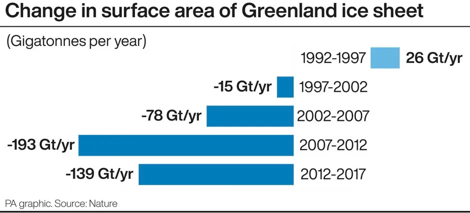
They found that the region has lost 3.8 trillion tonnes of ice since 1992 and added around 10.6 mm to the global sea levels.
Simulations showed that the rate of ice loss accelerated until 2013, after which it slowed down, coinciding with a period of cooler ocean and atmospheric temperatures.
Analysis indicated rise in air and ocean temperatures caused the surface ice to melt and increased glacial flow.
Reader Q&A: Could we live on Antarctica and Greenland if all the ice melted?
Asked by: Joe Elliott, Nottingham
If both ice sheets melted, the global sea level would rise by about 68m. This would put most of Europe underwater, along with large parts of Asia, Canada and South America. Greenland and Antarctica are currently both pushed downwards by the weight of the ice on top.
Once it melted, the land would eventually spring back, but this would take tens of thousands of years. In the meantime, Antarctica would resemble a mountainous archipelago like Australasia, and Greenland would be a central bowl below sea level, defended by a ring of mountains. With a warmer climate, there would definitely be some room for human settlement, but Antarctica is geologically very similar to the Andes so it’s never going to be prime real estate.
Read more:
According to the researchers, Greenland stores enough water to raise global sea levels by six metres and knowing how much of this ice is lost is key to understanding the effects and impact of climate change.
Guofinna Aoalgeirsdottir, a professor of glaciology at the University of Iceland and lead author on the IPCC’s sixth report, who was not involved in the study, said: “Satellite observations show that both melting and ice discharge from Greenland have increased since observations started.
“It is very important to keep monitoring the big ice sheets to know how much they raise sea level every year.”

