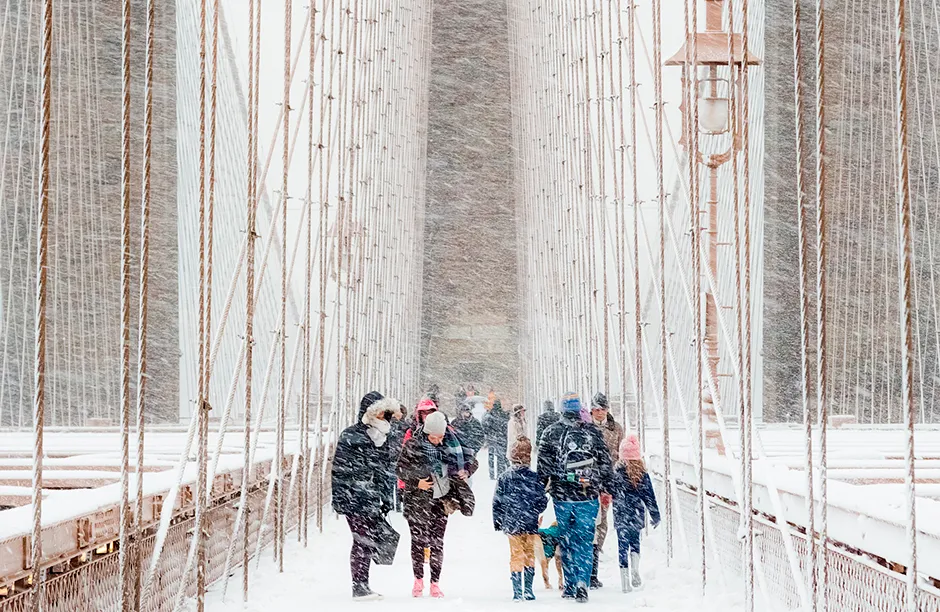
The Royal Meteorological Society’s Weather Photographer of the Year competition winners have just been announced, and has been won by a striking image of a blizzard as it hits Brooklyn Bridge, New York.
Here we bring you the winners and stand-outs from this year's batch of meteorological wonders.
Check out more of our photo stories
- 20 stunning microscopic photos from the Nikon Small World 2020 competition
- Tiger’s tender moment wins Wildlife Photographer of the Year
1
Blizzard in Brooklyn - Main Winner

In America, the National Weather Service defines a blizzard as a storm with wind speeds greater than 35mph and enough snow to reduce visibilities below ¼ mile (0.4 km) for at least 3 hours. The snow does not always need to be falling during the storm – strong winds can pick up snow that has fallen previously, creating a ground blizzard.
Conditions can be life-threatening, especially during a ‘whiteout’ where downdrafts and heavy snowfall combine to obscure the horizon, leading to disorientation. The cold temperatures can also cause frostbite or hypothermia in some cases.
2
Lake Baikal - Public Favourite Winner

Located in the Russian region of Siberia, Lake Baikal is the world’s deepest and largest freshwater lake – containing about one-fifth of the freshwater on Earth. During winter, average temperatures are around -21°C, whilst in summer they are roughly 11°C. With temperatures so cold for nearly half a year, the lake is covered in ice for almost five months.
As the temperature drops through winter, the uneven freezing of the lake results in some blocks being pushed up, which are then sculpted by the wind, sublimation, melting and refreezing. Lake Baikal is renowned for its many ice formations and their turquoise appearance.
3
Tea Hills - First Runner Up

What is the difference between fog and mist? Fog is a surface visibility of less than 1km, whilst mist is a visibility greater than 1km, when the relative humidity is above 95 per cent. Usually, we observe mist when the visibility is less than 10km, however there is no uniform definition around the world.
There are many different types of fog, one of which is valley fog. As the name suggests, this forms within valleys where cold, dense air collects and under the right conditions (cool temperature, calm wind, sufficient moisture, and clear sky) condenses to form fog. Valley fog can last for several days at a time, particularly during winter.
4
Monster Shelf Cloud - Second Runner-Up

A shelf cloud drapes itself across Umag in Croatia, associated with thunderstorms moving over the area. The shelf cloud is a low-level, horizontal, wedge-shaped cloud that occurs along the leading gust front in an intense thunderstorm.
Warm, moist air that rises within a storm’s updraft cools and condenses above the storm’s rain-cooled downdraft (or gust front), producing the shelf cloud. As it passes overhead, it is accompanied by gusty winds and an abrupt fall in temperature, with precipitation then following.
5
Frozen Life - Young Weather Photographer of the Year winner

The solubility of air in water is related to temperature: the cooler the water, the more air is dissolved within. However, this changes once water freezes, as gas solubility in ice is much less than in water.
Upon freezing, the dissolved air separates from the water and can become trapped by the forming ice to create bubbles. Typically, the faster the freezing rate, the greater the number and size of the bubbles.
6
Predawn thunderstorm - Finalist

Thunderstorms are associated with towering clouds known as cumulonimbus. These are formed through the process of convection, whereby heat and moisture are transported vertically in the atmosphere.
Three key ingredients are required to initiate convection: instability, moisture, and lift. The lifting mechanism can be from the Sun heating the earth’s surface; the air near the surface being forced to rise over higher ground; or instability within a weather front.
Worldwide, 16 million thunderstorms are estimated to occur each year, all of which can be accompanied by lightning, heavy rain, hail, strong winds and sudden changes in temperature.
7
Dam Wet - Finalist

Water cascades down the 21m high dam wall of Wet Sleddale reservoir near Shap in Cumbria, after a period of very heavy rain. Rain that falls at a rate greater than 4mm per hour is defined as heavy, whilst anything above 8mm per hour is termed very heavy.
Wet Sleddale Reservoir can store 2,300 million litres of water and was constructed to supply Manchester with water.
8
Final Stand - Finalist

Dust storms, or haboobs, are the result of a microburst – an intense column of sinking air within a thunderstorm, which as it hits the ground spreads out in all directions and carries dust particles at speeds of up to 60 miles per hour. The lofted particles can reach heights of 5000 ft and can extend up to 100 miles wide.
As long as there is enough dry, exposed land with loose sediment, dust storms can happen anywhere and are capable of reducing visibility to near zero in a matter of seconds. In Arizona, US, dust storms are most common in the early part of the monsoon and near agricultural areas.
This image captures an Arizona dust storm that raged across the state for over 200 miles in 2018, reaching its maximum height and density just in time to be illuminated by a stunning sunset.

